푸가 섬
Fuga Island 1927년 푸가 섬 조수계 | |
.svg) 푸가 섬 필리핀 내 위치 | |
| 지리 | |
|---|---|
| 좌표 | 18°52′21″N 121°22′44″E/18.87250°N 121.37889°E좌표: 18°52′21″N 121°22′44″E / 18.87250°N 121.37889°E/ |
| 군도 | 바부얀 제도 |
| 인접 수역 | 바부얀 해협 |
| 면적 | 70km2(27sqmi)[1] |
| 최고 고도 | 191m(627ft)[2] |
| 최고점 | 낭구링안 산 |
| 관리 | |
| 지역 | 카가얀 계곡 |
| 주 | 카가얀 |
| 시 | 아파리 |
| 인구통계학 | |
| 인구 | 1,939 (2020) [3] |
| 팝 밀도 | 27.7/km2(71.7/sq mi) |
푸가 섬(Puga Island)은 루손 북쪽에 위치한 섬이자 바랑게이로, 필리핀의 제2북단 섬인 바부얀 제도의 일부다.바랑게이 푸가 섬은 카가얀 주 아파리 시 관할의 42개 바랑게이 중 하나이다.
지리
푸가의 면적은 70평방킬로미터(27평방미터)[1]이고 인구는 2,015명이다.[4] 주요 정착지는 남해안의 나구이안(무사) 마을이다.가장 높은 봉우리는 북동쪽에 있는 난구링안 산으로, 고도가 191m(627ft)이다.[2]
인접한 바릿 섬(7평방킬로미터(2.7평방 미)과 마바그 섬과 함께 카가얀 아파리 시의 42개 바랑게이 중 하나이다.[5]본토 시군이 관할하는 바부얀 제도 중 유일한 하나이며, 다른 모든 섬은 칼라얀 시군을 이루고 있다.
역사
현재 푸가 섬은 푸가 섬 홀딩스가 소유하고 있다.스페인 시대 엔코미엔다 제도에 따라 도미니카 국의 소유였던 이 나라는 1898년 파리 조약 체결 후 필리핀으로 반환되었다.최초의 토지 소유권은 1908년 원본 증명서 제2호에 따라 발행되었으며, 필리핀 군도의 섬 정부는 이 섬과 주변 항구를 카가얀 특별경제구역(CEZA)과 공화국법 제7922호에 따라 자유항구의 일부로 경제구역으로 지정하였다.[6]
고고학
1978년 1월 31일부터 1978년 2월 22일까지 브라이언 E.스노우와 리처드 슈틀러 주니어는 푸가 모로 섬에서 고고학적 발굴을 실시했다.발굴 과정에서 발견된 것은 토기와 도자기, 도자기, 석기뿐이었다.[7]
군대 주둔
2020년 8월 7일 북부 루손 사령부는 이 섬에 해병 분대를 창설했다.또 20헥타르 분대에 대한 보호부두와 해군기지, 연근감시가 포함된 방위시설도 이 섬에 건설할 계획이다.[8]
참고 항목
참조
- ^ a b Genevieve Broad; Carl Oliveros. "Biodiversity and conservation priority setting in the Babuyan Islands, Philippines" (PDF). The Technical Journal of Philippine Ecosystems and Natural Resources. 15 (1–2): 1–30. Retrieved 18 April 2018.
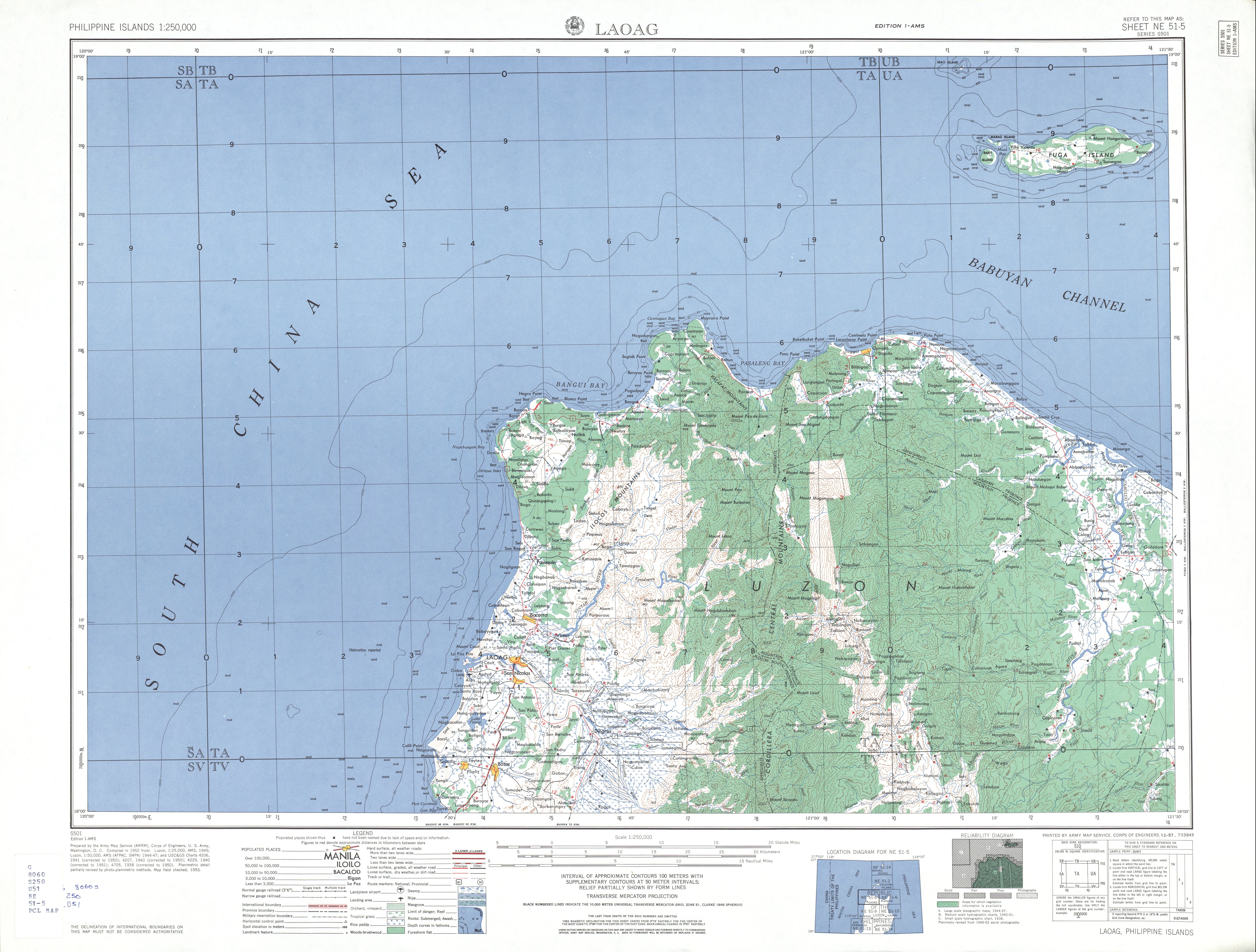
- ^ a b "NE 51-5 Laoag". Series S501, U.S. Army Map Service, 1954-. The University of Texas at Austin. Retrieved 18 April 2018.
- ^ Census of Population (2020). "Region II (Cagayan Valley)". Total Population by Province, City, Municipality and Barangay. PSA. Retrieved 8 July 2021.
- ^ Census of Population (2015). "Region II (Cagayan Valley)". Total Population by Province, City, Municipality and Barangay. PSA. Retrieved 20 June 2016.
- ^ Google (1 February 2020). "Fuga Island" (Map). Google Maps. Google. Retrieved 1 February 2020.
- ^ "Republic Act No. 7922: An act establishing a special economic zone and free port in the municipality of Santa Ana and the neighboring islands in the municipality of Aparri, province of Cagayan, providing funds therefor, and for other purposes" (PDF). ceza.gov.ph. Congress of the Philippines. February 24, 1995. Retrieved 18 April 2018.
- ^ Bryan E. Snow and Richard Shutler, Jr. (1985). The Archaeology of Fuga Moro Island:New Approaches for the Isolation and Explanation of Diagnostic Ceramic Assemblages in Northern Luzon. University of San Carlos. ISBN 9789711000479.
{{cite book}}: CS1 maint: 작성자 매개변수 사용(링크) - ^ "Navy safeguards northern islands". Philippine News Agency. 26 August 2020. Retrieved 28 May 2021.

