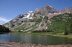
마룬 벨스 대 설원
Maroon Bells–Snowmass Wilderness| 마룬 벨스 대 설원 | |
|---|---|
 | |
| 위치 | 핏킨군과 군니슨군, 미국 콜로라도주 |
| 가장 가까운 도시 | 아스펜, CO |
| 좌표 | 39°05'N 107°00'W / 39.083°N 107.000°W[1] |
| 지역 | 181,535 에이커 (734.65 km2) |
| 설립된 | 1980 |
| 이사회 | 미국산림청 |
마룬 벨스 – 스노우매스 야생은 미국 콜로라도 주 중부 엘크 산맥에 위치한 야생 지역입니다. 181,535 에이커 (734.65 킬로미터2)의 황야는 1980년 거니슨과 화이트 리버 국유림에 세워졌습니다. 그 경계 내에는 100마일(160km)의 산책로, 콜로라도의 14개의 산책로 중 7개의 산책로, 그리고 12,000피트(3,700m)가 넘는 9개의 고개가 있습니다. 이 황무지는 마룬 벨(Maroon Bells)로 알려진 두 개의 봉우리와 스노우매스 산(Snowmass Mountain)의 이름을 따서 지어졌습니다.[2][3]
참고문헌
- ^ "Maroon-Bells Snowmass Wilderness". Geographic Names Information System. United States Geological Survey, United States Department of the Interior. Retrieved August 11, 2012.
- ^ "Maroon Bells-Snowmass Wilderness". Wilderness.net. Archived from the original on July 1, 2012. Retrieved August 11, 2012.
- ^ "Maroon Bells-Snowmass Wilderness Area". Colorado Wilderness. Retrieved August 11, 2012.


