A970길
A970 road | |
|---|---|
 | |
.jpg) | |
| 주요 접점 | |
| 노스엔드 | 북로 |
| 남쪽 끝 | 셈부르흐 |
| 도로망 | |
A970은 스코틀랜드 본토 셰틀랜드의 남쪽부터 북쪽까지 이어지는 단차도로다.[1][2][3] 그 길은 또한 Scalloway와[2] North Roe로 질주한다.[4]
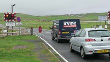
Sumburgh 공항 활주로가 있는 A970 도로 건널목. 이동식 장애물은 항공기가 착륙하거나 이륙할 때 닫힌다.
그 도로는 셈부르 공항의 활주로 끝을 가로지른다. 그 도로는 항공편이 이착륙할 때 장벽으로 폐쇄된다.
참조
- ^ Ordnance Survey. "View: Sheet 2, Shetland Islands (North Mainland) - Ordnance Survey One-inch to the mile maps of Great Britain, Seventh Series, 1952-1961". National Library of Scotland. National Library of Scotland. Retrieved 23 January 2016.
- ^ a b Ordnance Survey. "View: Sheet 4, Shetland Islands ( South Mainland) - Ordnance Survey One-inch to the mile maps of Great Britain, Seventh Series, 1952-1961". National Library of Scotland. National Library of Scotland. Retrieved 23 January 2016.
- ^ Ordnance Survey. "View: Sheet 1, Shetland Islands (Yell & Unst) - Ordnance Survey One-inch to the mile maps of Great Britain, Seventh Series, 1952-1961". National Library of Scotland. National Library of Scotland. Retrieved 23 January 2016.
- ^ Shetland - Mainland North West (Map) (A1 ed.). 1:25000. Southampton: Ordnance Survey. 2007. § South Sheet. ISBN 9780319240052. OCLC 1043106388. Explorer Map 469.


