세로 시엔토
Cerro Ciento| 세로 시엔토 | |
|---|---|
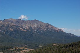
 세로 시엔토는 사진 왼쪽에서 가장 높은 봉우리다. | |
| 최고점 | |
| 표고 | 11,420ft(3,400m)[1] |
| 두각을 나타남 | 554 ft(평방미터 m)[1] |
| 좌표 | 43°51′49″N 114°35′00″w/43.8635°N 114.5834°W좌표: 43°51′49″N 114°35′00″W / 43.8635°N 114.5834°W |
| 지리 | |
| 상위 범위 | 볼더 산맥 |
| 토포 지도 | USGS 이즐리 온천 |
| 등반 | |
| 가장 쉬운 경로 | 단순 스크램블, 클래스 2 |
세로 시엔토는 해발 3,400m의 아이다호 볼더 산맥에서 10번째로 높은 봉우리다.블레인과 커스터 카운티의 경계에 있는 쏘우토트 국립 휴양지의 헤밍웨이-볼더스 황야에 위치한 세로 시엔토는 이즐리 봉우리에서 북쪽으로 약 0.8마일(1,300m) 떨어져 있다.세로 시엔토는 아이다호에서 80번째로 높은 봉우리다.[2][3]
가장 쉬운 경로는 아이다호 주 고속도로 75번 도로에서 접근할 수 있는 스프링 크릭 로드 끝에서 난 노선의 2등급 쟁탈전이다.고속도로와 갈레나 정상에서 봉우리가 쉽게 보인다.[2][4][5]
참조
- ^ a b "Cerro Ciento, Idaho". Peakbagger.com. Retrieved December 19, 2012.
- ^ a b Sawtooth National Forest (Map) (1998 ed.). Sawtooth National Forest, U.S. Forest Service.
- ^ "The 100 Highest Peak". Idaho: A Climbing Guide. Retrieved December 19, 2012.
- ^ "Cerro Ciento". Idaho Summits. Archived from the original on March 4, 2016. Retrieved December 19, 2012.
- ^ "Cerro Ciento". SummitPost.org. Retrieved December 19, 2012.


