꼬불꼬불한 강 국립 초원
Crooked River National Grassland| 꼬불꼬불한 강 국립 초원 | |
|---|---|
 | |
 | |
| 위치 | 미국 오리건 주, 제퍼슨 군 |
| 가장 가까운 도시 | 오리건 주 |
| 좌표 | 44°32ºN 121°07ºW/44.54°N 121.11°W[1]좌표: 44°32°N 121°07°W / 44.54°N 121.11°W / [1] |
| 지역 | 173,629에이커(702.65km2)[2] |
| 이사회 | 미국 산림청 |
| 웹 사이트 | 오초코 국유림 & 꼬불꼬불한 강 국유초원 |
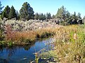
크리프 리버 국립 초원은 미국 오레곤 주 북중부에 있는 제퍼슨 카운티에 위치한 국립 초원이다.이곳은 173,629에이커(70,265ha)의 면적을 가지고 있다.이곳에는 두 개의 국가 야생 및 경치 강, 데슈트 강과 꼬불꼬불한 강이 있습니다.이 초원은 프리네빌의 산림청에서 오초코 국유림과 함께 관리되고 있다.가장 가까운 [2]도시인 마드라스에는 지역 경비원 지구 사무소가 있습니다.
레퍼런스
- ^ "Crooked River National Grassland". Geographic Names Information System. United States Geological Survey. Retrieved December 9, 2012.
- ^ a b "About the Forest". U.S. Forest Service. Retrieved January 1, 2015.
갤러리

데슈트강과 꼬불꼬불한 강의 협곡으로 고립된 '섬'


외부 링크