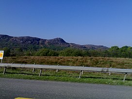
컬레우 산맥
Curlew Mountains| 컬레우 산맥 | |
|---|---|
 컬레우 고개 | |
| 최고점 | |
| 표고 | 259m(제곱 피트) |
| 두각을 나타남 | 197m(646ft) |
| 지리 | |
| 위치 | 로즈커먼 & 슬리고, 아일랜드 |
| 상위 범위 | 컬레우 산맥 |
컬레우 산맥(Irish:An Corrshliabh, ' 거칠거나 험한 산'이라는 뜻)은 코나흐트 북동부의 보일과 캐슬발드윈 사이에 위치한 저지대 언덕의 한 폭이다.[1]
토포니미
Curlew라는 이름을 산에 붙이는 것은 Curlew 새와 관련이 있는 것이 아니라 "계단 편 뾰족한 산"을 의미하는 아일랜드인: corrshliabh와 관련이 있을 수 있다.[2]
지리
지질학적으로 컬레우 산맥은 데보니아 사암과 주변 카본리퍼스 석회석보다 단단한 대기업으로 이루어져 있어 고지대 특색으로 보인다.[3]
역사
레드 휴 오도넬이 이끄는 아일랜드군이 2000여 명의 영국군을 격파한 컬레우 패스 전투는 1599년 8월 15일 이곳에서 치러졌다.[4]
참조
| 위키미디어 커먼즈에는 컬루 산맥과 관련된 미디어가 있다. |
- Cotton, D (2017a). "Curlew Mountains". IT Sligo. Archived from the original on 8 October 2017. Retrieved 8 October 2017.
{{cite web}}: CS1 maint : 부적합한 URL(링크) - Cotton, D (2017b). "Curlew Mountains (419 to 359 Ma)". IT Sligo. Archived from the original on 8 October 2017. Retrieved 8 October 2017.
{{cite web}}: CS1 maint : 부적합한 URL(링크) - D'Alton, John (1845). The history of Ireland, from the earliest period to the year 1245, when the Annals of Boyle, which are adopted and embodied as the running text authority, terminate: With a brief essay on the native annalists, and other sources for illustrating Ireland, and full statistical and historical notices of the barony of Boyle. Dublin: author.
- Mac Coitir, Niall (27 February 2017). Ireland's Birds: Myths, Legends & Folklore. The Collins Press. ISBN 978-1848892989. OCLC 1078888226.


