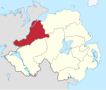
데리시티와 스트라반
Derry City and Strabane좌표: 54°55′37″N 7°25′26″w / 54.927°N 7.424°W
데리시티와 스트라반 | |
|---|---|
구 | |
 | |
| 소버린 주 | 영국 |
| 제헌국 | 북아일랜드 |
| 상태 | 구 |
| Incorporated | 2015년 4월 1일 |
| 정부 | |
| • 유형 | 구의회 |
| • 차체 | 데리 시 스트라바네 구 |
| 면적 | |
| • 합계 | 478 sq mi(1,238 km2) |
| 인구 (2019년 중반) | |
| • 합계 | 150,679 |
| • 밀도 | 320/sq mi(120/km2) |
| 시간대 | UTC0(GMT) |
| • 여름(DST) | UTC+1(BST) |
| 웹사이트 | www |
데리시티와 스트라바네는 2015년 4월 1일 데리 구와 스트라바네 구를 합병해 만든 지방 자치구다.[1] 이 섬은 북아일랜드 북서부의 대부분을 차지하고 있다. 지방 당국은 데리 시와 스트라바네 지방 의회다.
지리
북아일랜드 북서부에 위치하고 있으며 런던데리와 타이론 주의 일부를 포함하고 있으며, 아일랜드 공화국의 다인갈 카운티와 국경을 접하고 있다.[2] 그 지역은 인구가 150,679명이다.[3] 신구의 명칭은 2008년 9월 17일에 발표되었다. 데리 시 외곽에는 타이론 카운티의 스트라바네 시장 마을에서 시작되는 스페린 산맥의 넓은 면적이 있는 시골지역이 대부분이다.
소분류
데리 시와 스트라바네 구는 다음과 같은 지역 선거구(2014년)로 구성되며,[4] 각각 지역 공동체 계획을 위해 일부 지역구로 구성된다.
- 발랴넷: 컬모어, 샨탈로, 칸힐, 갈리아그, 스케지;[5]
- 더그:[7] 뉴타운스튜어트, 킬러, 시온 밀스, 카스트레더그, 클래디, 빅토리아 브리지, 아르드스트로우[6] 및 스트라반 타운 지역 일부
- Faugh: 뉴빌딩스,[8] 에글린튼, 클라우디, 에나그, 매헤라마손, 캠피, 브레디
- 포일스라이드: 밸리매그로아르티, 포일스프링스, 노스랜드, 로즈마운트, 스프링타운,[9] 마담은행
- Sperrin: Flumbridge,[11] Artigarvan, Donemana, Park, Sperrin, Ballynamalaight, Cranah[10] 및 Strabane Town 지역 일부
- The Moor: 크레건, 브랜디웰, 시티 월스, 셔리프스 마운틴;[12]
- 워터사이드: Drumahoe, Victoria, Caw, Ebrington, Kilfennan, Lisnagelvin, Clondermot.[13]
지방 정부
데리 시와 스트라바네 구의회가 데리 시의회와 스트라바네 구의회를 대체했다. 새 선거구의 첫 번째 선거는 원래 2009년 5월에 실시될 예정이었으나 2008년 4월에 북아일랜드 장관 숀 우드워드는 예정되었던 2009년 지방 선거는 2011년까지 연기될 것이라고 발표했다.[14] 첫 선거는 2014년 5월 22일에 치러졌고 의회는 2015년 4월 1일까지 그림자 권한으로 활동했다.
운송
그 지역은 NI 철도에 의해 운영되는 런던데리 기차역이 운행한다. 그 지역은 또한 이전에 벨파스트-데리 노선을 따라 에글린튼 철도역(1973년 폐쇄)에 의해 운행되었다.
참고 항목
참조
- ^ "Population Estimates for UK, England and Wales, Scotland and Northern Ireland, Mid-2019". Office for National Statistics. 6 May 2020. Retrieved 6 May 2020.
- ^ Local Government Boundaries Commissioner for Northern Ireland (26 June 2009). "Introduction" (PDF). Review of Northern Ireland Local Government Boundaries - Final Recommendations Report. Archived from the original (PDF) on 21 July 2011. Retrieved 8 July 2010.
- ^ "Provisional Recommendations of the Local Government Boundaries Commissioner for Northern Ireland". LGBC. Archived from the original on 20 September 2008. Retrieved 26 September 2008.
- ^ Northern Ireland Statistics and Research Agency. "Area Profile for District Electoral Areas". NINIS: Northern Ireland Neighbourhood Information Service. Retrieved 15 January 2015.
- ^ Derry City and Strabane District Council. "Ballyarnett". Local Community Plans. Retrieved 15 January 2015.
- ^ Derry City and Strabane District Council. "Derg". Local Community Plans. Retrieved 15 January 2015.
- ^ Derry City and Strabane District Council. "Strabane Town". Local Community Plans. Retrieved 15 January 2015.
- ^ Derry City and Strabane District Council. "Faughan". Local Community Plans. Retrieved 15 January 2015.
- ^ Derry City and Strabane District Council. "Foyleside". Local Community Plans. Retrieved 15 January 2015.
- ^ Derry City and Strabane District Council. "Sperrin". Local Community Plans. Retrieved 15 January 2015.
- ^ Derry City and Strabane District Council. "Strabane Town". Local Community Plans. Retrieved 15 January 2015.
- ^ Derry City and Strabane District Council. "The Moor". Local Community Plans. Retrieved 15 January 2015.
- ^ Derry City and Strabane District Council. "Waterside". Local Community Plans. Retrieved 15 January 2015.
- ^ 북아일랜드 선거 연기, 2008년 4월 25일 BBC 뉴스, 2008년 4월 27일 접속


