카라코람 고장 시스템
Karakoram fault system
카라코람 단층은 인도와 아시아를 가로지르는 히말라야 지역의 사선 단층 시스템이다. 단층을 따라 미끄러진 부분은 히말라야 호를 방사형으로 확장하고,[2] 파미르 산맥의 북쪽 움푹 들어간 곳,[3] 티베트 고원의 동쪽 측면 돌출부를 수용한다.[4][5] 현재 판의 움직임으로 볼 때 인도 판과 유라시아 판의 수렴은 히말라야-파미르 서부 지역에서 연간 약 44±5mm이고 히말라야 동부 지역에서는 연간 약 50±2mm임을 알 수 있다.[6]
기원
카라코람 단층 조성은 한때 아시아와 인도의 두 현대 대륙을 갈라놓았던 고대 테티스 해협이 폐쇄되면서 시작되었다. 카라코람 단층 자체는 인더스-야룽 수태 지역에서 끝날 가능성이 있는 곳을 제외하고는 판 경계를 추적하지 않는다.[4] 원래의 추력은 1700만 년에서 2000만 년 전 사이에 지금의 파미르 산맥에 있는 기존의 추력 결함을 연결함으로써 일어났다.
진화
카라코람 단층은 약 2천만년 전부터 시작된 우측 측면 미끄러짐 단층이었다. 약 1400만년 전에 그 결함은 주로 정상적인 결함으로 바뀌었다. 이것은 아르곤 데이트를 기반으로 한다.[7] 카라코람 단층은 1천만년에서 1천 1백만년 전까지만 해도 트랜스 텐션이 되어 티베트까지 남서쪽으로 확장되었다. 남서쪽 연장은 현재의 카일라스 산 근처에서 활동 중인 카일라스 스러스트를 가로지르는 카라코람 단층으로 표시되어 있다.[7][1]
길이
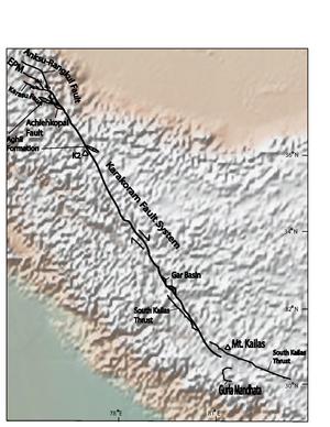
카라코람 중심부,[12][13][14][15] 인근 라다흐잔스카르,[16] 티베트 남부 지역에서 지도를 바탕으로 카라코람 단층을[11] 따라 백악기-에오세 화강암 욕조석이 1000km 이상 상쇄되었음을 시사한다. 어떤 연구자들은 이것이 결코 같은 욕조의 일부가 아니었던 화강암을 연관시키기 때문에 부정확할 수 있다고 제안한다.[4] 다른 연구자들은 U-Pb 데이트를 기준으로 2300만년 전부터 600km의 우측 횡방향 미끄러짐을 보여 왔으며, 아마도 3400만년 전부터 시작되었을 것이다. 이 모델의 슬립은 대규모 보디나주뿐만 아니라 인더스-얄루 봉합 구역으로 옮겨졌다.[17] 1990년대 초의 연구는 이 전표가 남 티베트 분견소로 옮겨졌다는 것을 시사했다.[18] 또 다른 제안은 카라코람 단층이 쿤룬 욕조에서 고생대 후기 곡류들의 상쇄로 측정했을 때 최소 500km 이상 상쇄된다는 것이다.[11] 대부분의 연구자들은 낮은 전표 추정치에 동의하는 경향이 있다. 결함을 따라 총 오프셋을 측정하는 데 있어 주요 장애물은 실제로 결함의 일부인 부분과 분리된 결함을 결정하는 데 있다. 현재 일부 연구자들은 카라코람 단층이 카일라스 산의 인더스-얄루 봉합 구역으로 합쳐져 종착된다고 믿고 있다.[4] 다른 연구자들은 또한 남동부 지역에 있는 구를라 만다타 분리를 단층에 추가했다.[5]
북서부 세그먼트
카라코람 단층의 북서부는 다른 지역에 비해 논란이 훨씬 적다. 타지키스탄과 신장성의 경계를 따라 파미르 산맥에 있는 미우지 분지의 연장선에서 종착한다. 이 북서 세그먼트에서 카라코람 단층은 현재 대부분 정상 고장 모션과 우측 측면 스트라이크-슬립 오프셋을 가지고 있다.[4] 카라코람 단층 이 부분의 슬립은 아길 형성의 오프셋으로 측정했을 때 약 150 km로 측정된다. 아길 형성은 화석화된 탄산염 형질이다. 파미르 지역에 들어가기 전에 카라코람 단층은 두 개의 뚜렷한 단층으로 갈라진 것으로 생각된다. 이러한 결함은 카라코람의 주요 결점 그 자체, 그리고 아에헤코파이의 결점이다.[10]
남동부 세그먼트
대부분의 사람들은 결함의 남동 부분이 티베트 서부의 인더스 봉수대에 병합되어 평행하게 된다는 것에 동의한다. 카라코람 단층의 남쪽 구간은 인더스 강과 남 카일라스 스러스트와 같은 지질학적 특징의 상쇄에서 120km의 덱스트랄 운동만이 뚜렷이 나타나며,[1] 이 지역의 균주는 거의 전적으로 인더스 수처리 구역의 바로 남쪽에 있는 히말라야의 남북 단축에 의해 수용된다는 것을 보여준다.[4] 티베트 서부의 네이젠 가 분지에도 카라코람 단층부를 따라 미끄러지는 곳이 있다. 분지는 고장의 약 1km 넓이의 북쪽 지역 내에 있으며, 오역적 정상 결함을 포함하고 있다.[9] 구를라 만다타 고장 시스템은 남쪽 끝단에 있는 카라코람 고장 시스템 내에 포함되는 것으로 생각되며, 이는 고장의 남쪽 끝의 폭이 약 36km가 되는 원인이 된다.[19] 저각 정상 결함 시스템인 구라 만다타 분리를 따라 대피한 결과 36~66km의 미끄러짐이 발생했음을 알 수 있다.[5]
참고 항목
- 히말라야의 지질학
- 네팔의 지질학
- 인더스 강 - 난가 파르밧의 침식으로 인해 하부 지각 암석이 빠르게 상승하고 있다.
- 수틀레지 강 - 인더스 강과 유사한 소규모 침식
- 북쪽의 티베트 고원(티베트 지리에서도 논의)
- 팔로테시스
참조
- ^ a b c d Murphy, M.; A. Yin; P. Kipp; T. M. Harrison; D. Lin; J. H. Guo (2000). "Southward propagation of the Karakoram fault system, southwest Tibet: Timing and magnitude of slip" (PDF). Geology. 28 (5): 451–454. Bibcode:2000Geo....28..451M. doi:10.1130/0091-7613(2000)28<451:SPOTKF>2.0.CO;2. Archived from the original (PDF) on 2013-12-02. Retrieved 2013-11-21.
- ^ Murphy, M. A.; P. Copeland (2005). "Transtentional deformation in the central Himalay and its role in accommodating growth of the Himalayan orogeny". Tectonics. 24 (4): n/a. Bibcode:2005Tecto..24.4012M. doi:10.1029/2004TC001659.
- ^ Sobel, E. R.; L. M. Schoenbohm; J. Chen; R. Thiede; D. F. Stockli; M. Sudo; M. R. Strecker (2011). "Late Miocene-Pliocene deceleration of dextral slip between Pamir and Tarim: Implications for Pamir orogensis". Earth and Planetary Science Letters. 304 (3–4): 369–378. Bibcode:2011E&PSL.304..369S. doi:10.1016/j.epsl.2011.02.012.
- ^ a b c d e f Searle, M. P. (February 1996). "Geological evidence against large scale pre-holocene offsets along the Karakoram fault: Implications for the limited extrusion of the Tibetan Plateau". Tectonics. 15 (1): 171–186. Bibcode:1996Tecto..15..171S. doi:10.1029/95TC01693.
- ^ a b c Murphy, Mike A.; A. Yin; P. Kapp; T. M. Harrison; C. E. Manning (2002). "Structural and thermal evolution of the Gurla Mandhata metamorphic core complex, southwest Tibet". Geological Society of America Bulletin. 35 (114): 428–447. doi:10.1130/G23774A.1.
- ^ Demets, C. (1990). "Current Plate Motions". Geophysical Journal International. 101 (1): 425–478. Bibcode:1990GeoJI.101..425D. doi:10.1111/j.1365-246X.1990.tb06579.x.
- ^ a b Valli, Franck; Nicholas Arnaud; Phillipe Hervé Leloup; Edward R. Sobel; Gweltaz Mahe'o; Robin Lacassin; Stephane Guillot; Haibing Li; Paul Tapponnier; Zhiqin Xu (2007). "Twenty million years of continuous deformation along the Karakoram fault, Western Tibet: A Thermochronological analysis" (PDF). Tectonics. 26 (4): 1–26. Bibcode:2007Tecto..26.4004V. doi:10.1029/2005TC001913.
- ^ Searle, M. P.; R. F. Weinberg; W. J. Dunlap (1998). "Transpressional tectonics along the Karakoram fault zone, northern Ladakh: Constraints on Tibetan extrusion, in continental transpressional and transtensional tectonics". Geological Society of America Special Publication. 135: 307–326. doi:10.1144/gsl.sp.1998.135.01.20. S2CID 130363239.
- ^ a b Sanchez, Veronica; M. Murphy; W. R. Dupré; Lin Ding; Ran Zhang (2010). "Structural evolution of the Neogene Gar Basin, Western Tibet: Implications for releasing bend development and drainage patters". Geological Society of America Bulletin. 122 (5–6): 926–945. Bibcode:2010GSAB..122..926S. doi:10.1130/B26566.1.
- ^ a b Robinson, A. C. (2009). "Geologic offsets across the northern Karakorum fault: Implications for its role and terrane correlations in the western Himalayan-Tibetan orogeny" (PDF). Earth and Planetary Science Letters. 279 (1–2): 123–130. Bibcode:2009E&PSL.279..123R. doi:10.1016/j.epsl.2008.12.039.[영구적 데드링크]
- ^ a b Peltzer, G.; P. Tapponnier (1988). "Formation and evolution of strike-slip faults, rifts, and basins during the India-Asia collision: An experimental approach" (PDF). Journal of Geophysical Research: Solid Earth. 93 (15b): 15085–15117. Bibcode:1988JGR....9315085P. doi:10.1029/JB093iB12p15085.[영구적 데드링크]
- ^ Searle, M. P.; A. J. Rex; R. Tirrul; D. C. Rex; A. Barnicoat; B.F. Windley (1989). "Metamorphic, magmatic and tectonic evolution of the central Karakoram in the Biafo-Baltoro-Hushe regions of north Pakistan". Geological Society of America Papers. 232. 232: 47–73. doi:10.1130/SPE232-p47. ISBN 978-0-8137-2232-0.
- ^ Searle, M. P.; R.R. Parrish; R. Tirrul; D.C. Rex (1990). "Age of crystallization and cooling of the K2 gneiss in the Baltoro Karakoram". Geological Society of London. 147. 147 (4): 603–606. Bibcode:1990JGSoc.147..603S. doi:10.1144/gsjgs.147.4.0603. S2CID 129956294.
- ^ Searle, M. P. (1991). Geology and Tectonics of the Karakoram Mountains. New York: John Wiley. p. 358.
- ^ Searle, M. P.; R. Tirrul (1991). "Structural and thermal evolution of the Karakoram crust". Geological Society of London. 148. 148 (1): 65–82. Bibcode:1991JGSoc.148...65S. doi:10.1144/gsjgs.148.1.0065. S2CID 128818804.
- ^ Searle, M. P. (1986). "Structural evolution and sequence of thrusting in the High Himalayan Tibetan Tethys and Indus suture zones of Zanskar and Ladakh, western Himalaya". Structural Geology. 8 (8): 923–936. Bibcode:1986JSG.....8..923S. doi:10.1016/0191-8141(86)90037-4.
- ^ Lacassin, Robin; Frank Valli; Nicholas Arnaud; P.Hervé Leloup; Jean Louis Paquette; Li Haibing; Paul Tapponnier; Marie-Luce Chevalier; Stephane Guillot; Gweltaz Maheo; Zhiqin Xu (2004). "Large-scale geometry, offset and kinematic evolution of the Karakoram fault, Tibet" (PDF). Earth and Planetary Science Letters. 219 (3–4): 255–269. Bibcode:2004E&PSL.219..255L. doi:10.1016/S0012-821X(04)00006-8. Archived from the original (PDF) on 2013-12-03. Retrieved 2013-11-21.
- ^ Pecher, A. (1991). "The contact between the Higher Himalaya crystallines and the Tibetan sedimentary series: Miocene large-scale dextral shearing". Tectonics. 10 (3): 587–598. Bibcode:1991Tecto..10..587P. doi:10.1029/90TC02655.
- ^ Murphy, M.; A. Yin (2003). "Structural evolution and sequence of thrusting in the Tethyan fold-thrust belt and Indus-Yalu suture zone, southwest Tibet". Geological Society of America Bulletin. 115 (1): 21–34. Bibcode:2003GSAB..115...21M. doi:10.1130/0016-7606(2003)115<0021:SEASOT>2.0.CO;2.


