수문함 주립공원
Sluice Boxes State Park| 수문함 주립공원 | |
|---|---|
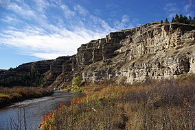
 벨트 크리크 협곡의 절벽 | |
| 위치 | 미국 몬태나 주 캐스케이드 카운티 |
| 가장 가까운 마을 | 몬태나 주의 벨트 |
| 좌표 | 47°11′32″N 110°56′29″W / 47.19222°N 110.94139°W좌표: 47°11′32″N 110°56′29″W / 47.19222°N 110.94139°W/ [1] |
| 면적 | 1454에이커(5.88km2)[2] |
| 표고 | 4,035ft(1,230m)[1] |
| 지정 | 몬태나 주립공원 |
| 확립된 | 1974[3] |
| 관리자 | 몬태나 물고기, 야생동물 & 공원 |
| 웹사이트 | 수문함 주립공원 |
슬루이스 박스 스테이트 파크는 미국 몬태나 주의 리틀 벨트 마운틴에 있는 공공 휴양지로, 킹스 힐 경치의 벨트 남쪽 12마일(19km) 지점에 위치해 있다. 주 공원은 벨트 크리크 협곡의 가장 북쪽 8마일이 리틀 벨트 마운틴에서 굽이쳐 나가는 큰 절벽과 선반에 의해 강조되어 있다. 그 지역의 광업과 철도의 날들의 잔해가 협곡 곳곳에서 발견된다. 그 공원은 낚시, 하이킹, 부유, 소풍, 그리고 시골 캠핑을 제공한다.[4]
참조
- ^ a b "Sluice Boxes". Geographic Names Information System. United States Geological Survey.
- ^ "Sluice Boxes State Park". Montana Kids. Travel Montana. Retrieved May 28, 2018.
- ^ "Park Origin by Date". Montana State Parks. 2014. Archived from the original on January 1, 2020. Retrieved May 28, 2018.
- ^ "Sluice Boxes State Park". Montana State Parks. Retrieved August 17, 2021.
외부 링크
| 위키미디어 커먼즈에는 슬루이스 박스 스테이트 파크와 관련된 미디어가 있다. |
- 수문함 주립공원 몬타나 물고기, 야생동물 & 공원
- 수문함 주립공원 트레일 맵 몬타나 물고기, 야생동물 & 공원


