테카테 시당국
Tecate Municipality테카테 시당국 Municipio 드 테카테. | |
|---|---|
| Motto(s): Paraíso 산업 드 기원전 (바하 캘리포니아의 산업 파라다이스) | |
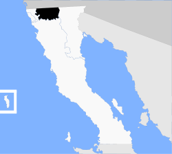
 테카테. 미국의 바하 캘리포니아에 위치. | |
| Coordinates: 32°34′N 116°38′W / 32.567°N 116.633°WCoordinates:32°34′N116°38′W/32.567°N 116.633°W/32.567, -116.633. | |
| 나라 | 멕시코 |
| 주 | 바하 캘리포니아 |
| 시립 좌석 | 테카테 |
| 도시 큰 | 테카테 |
| 자치구를 설립했다 | 12월 29일 1953[1] |
| 정부 | |
| • 지방 자치 대통령 | Cesar라파엘 모레노 곤잘레스(PRI). |
| 면적 | |
| • 합계 | 3,079.0km2(1,188.8sq 미). |
| 인구 (2020년) | |
| • 합계 | 108,440 |
| • 밀도 | 35/km2(91/sq mi) |
| 데이터 원본:[2] | |
| 시간대 | UTC−8(노스웨스트(미 태평양)) |
| 하계(일광 절약 시간)• | UTC−7(북서) |
| INEGI 코드 | 003 |
| 웹사이트 | (스페인어로) Gobierno 시 드 테카테, 바하 캘리포니아. |
| 출처: 엔시클로페디아 데 로스 무니시오스 데 메렉시오 | |
테카테는 멕시코 바하 캘리포니아 주에 있는 자치단체다. 시립 좌석은 테카테 시에 위치해 있다. 2020년 인구조사에 따르면 10만8,440명의 인구를 가지고 있었다.[3] 시군의 면적은 3,079.0 km²(1,188.8 sq mi)이다.
자치구
시군은 행정적으로 시 의석인 테카테 외에 6개 자치구로 세분된다.
인구통계학
2020년 현재 시군의 인구는 총 10만8,440명이다.[8]
2010년 현재 테카테 시는 6만4764명의 인구를 가지고 있다.[9] Other than the city of Tecate, the municipality had 964 localities, the largest of which (with 2010 populations in parentheses) were: Lomas de Santa Anita (6,604), Nueva Colonia Hindú (4,431), classified as urban, and Cereso del Hongo (4,278), Luis Echeverría Álvarez (El Hongo) (2,411), classified as urban, and Hacienda Tecate (1,871), Valle de las팔마스(1,860), 라 루머로사(1,836), 마클로비오 에레라(콜로니아 아비키아온)(1,219), 알폰소 가르손(그란하스 파밀리아레스)(1,188), 엘 미라도르(1,171) 등이 농촌으로 분류됐다.[9]
인접 시·군
참조
- ^ (in Spanish) pp. 78–79, La Transformación de Baja California en Estado, 1931–1952 Archived September 29, 2011, at the Wayback Machine, Lawrence Douglas Taylor Hansen, Estudios Fronterizos, 1, No. 1 (Jan–June 2000), UABC, Mexicali, pp. 47–87.
- ^ https://www.inegi.org.mx/app/areasgeograficas/#tabMCcollapse-Indicadores
- ^ https://www.inegi.org.mx/app/areasgeograficas/#tabMCcollapse-Indicadores
- ^ "Localidades y su población por municipio según tamaño de localidad" (PDF) (in Spanish). INEGI. Archived from the original (PDF) on August 31, 2018. Retrieved July 15, 2017.
- ^ "Número de habitantes". INEGI (National Institute of Statistics and Geography). Archived from the original on July 2, 2017. Retrieved July 15, 2017.
- ^ "Tabulados de la Encuesta Intercensal 2015" (xls) (in Spanish). INEGI. Archived from the original on December 31, 2017. Retrieved July 15, 2017.
- ^ "INEGI. Censo de Población y Vivienda 2020. Tabulados del Cuestionario Básico – Aguascalientes" [INEGI. 2020 Population and Housing Census. Basic Questionnaire Tabulations – Aguascalientes] (Excel) (in Spanish). INEGI. 2020. pp. 1–4. Archived from the original on January 28, 2021. Retrieved January 27, 2021.
- ^ https://www.inegi.org.mx/app/areasgeograficas/#tabMCcollapse-Indicadores
- ^ Jump up to: a b "Tecate". Catálogo de Localidades. Secretaría de Desarrollo Social (SEDESOL). Retrieved April 23, 2014.
- (스페인어) 2010년 인구조사, INEGI: 국립통계연구소, Geographia e Informatica.
- (스페인어) Tecate, Enciclopedia de los Municios de México, Nacional Para el Federalismo y El Desarrollo Republic, SEGOB. 2007년 11월 15일 전화 접속.
외부 링크
- (스페인어) Gobierno Unitedital de Tecate, Baja California 정부 공식 웹사이트.


