코퍼 강 (알라스카 주
Copper River (Alaska)| 코퍼 강 | |
|---|---|
 | |
| 위치 | |
| 나라 | 미국 |
| 주 | 알래스카 |
| 물리적 특성 | |
| 출처 | |
| • 위치 | 브란젤 산의 구리 빙하 |
| • 좌표 | 62°10′39″N 143°49′05″w / 62.17750°N 143.81806°W |
| • 고도 | 4,380ft(1,380m) |
| 입 | |
• 위치 | 코퍼베이 오브 태평양 |
• 좌표 | 60°23′19″N 144°57′39″w / 60.38861°N 144.96083°W좌표: 60°23′19″N 144°57′39″W / 60.38861°N 144.96083°W/ . |
• 고도 | 0 ft(0m) |
| 길이 | 290 mi (190 km) |
| 분지크기 | 24,000 sq mi(62,000km2) |
| 방전 | |
| • 평균 | 57,400u ft/s(1,540m3/s) 입구에서 |

The Copper River or Ahtna River (/ˈɑːtnə/), Ahtna Athabascan ‘Atna’tuu ([ʔatʰnaʔtʰuː]), "river of the Ahtnas",[1] Tlingit Eeḵhéeni ([ʔìːq.híː.nì]), "river of copper",[2][3] is a 290-mile (470 km) river in south-central Alaska in the United States. 그것은 알래스카 만으로 브란젤 산맥과 추가치 산맥의 넓은 지역을 배수한다.[4] 이곳은 광범위한 델타 생태계와 함께 세계에서 가장 높이 평가받는 야생 연어의 다산적인 운영으로 유명하다.[5] 이 강은 미국에서 10번째로 큰 강으로, 하구의 평균 방류량에 따라 순위가 매겨진다.[6]
설명
코퍼 강은 브란젤 산의 북동쪽에 위치한 코퍼 빙하로부터, 브란젤-세인트 엘리아스 국립공원 내에 있는 브란젤 산맥의 코퍼 빙하로부터 솟아 있다.[7] 샌포드 산의 동쪽에 놓여 있는 골짜기에서 거의 정북쪽으로 흘러가는 것으로 시작하여 서쪽으로 방향을 돌려 브란젤 산맥의 북서쪽 가장자리를 형성하여 멘타스타 산맥에서 북동쪽으로 분리한다.[8] 넓은 습지 평원을 지나 치티나 강(Ahtna Athabascan Tsedi Na'[tʃɛ.diː])에 의해 남동쪽으로 계속 돈다.néʔ] < tsedi "copper" + na" "river").[8][9]
.jpeg)
구리 강은 길이가 약 290마일(470km)이다.[10] 그것은 마일당 평균 약 12피트(2.3m/km)의 속도로 떨어지고, 웨스트 버지니아 주 크기의 24,000평방마일(62,000km2) 이상의 배수구가 나온다.[10][11] 그 강은 시간당 평균 7마일로 흐른다.[11]
치티나 산맥과 합류한 하류에서 그것은 남서쪽으로 흐르며, 코르도바 봉우리 동쪽의 추가치 국유림 내에 있는 추가치 산맥의 좁은 빙하 줄의 틈새를 통과한다.[12] 구리강 하구에서 방사되는 높이가 최대 250피트(76m)에 이르는 선형 사구의 넓은 지역이 있다.[13][14] 마일스 빙하와 차일즈 빙하 둘 다 강으로 직행한다.[15] 코르도는 코르도바 남동쪽 알래스카 만에 진입해 폭 80km에 가까운 삼각주를 형성한다.[13]
역사
이 강의 이름은 알래스카 원주민들이 사용했던 상류 지역의 풍부한 구리 퇴적물에서 유래되었다. 그리고 후에 러시아 제국과 미국의 정착민들에 의해 사용되었다.[16] 구리 자원의 채취는 강 하구의 항행 장애로 문제가 있었다.[8][16] 1908년부터 1911년까지 코르도바에서 상류 계곡까지 구리강과 노스웨스턴 철도가 건설되면서 특히 1898년에 발견된 케네컷 광산에서 광물자원을 광범위하게 추출할 수 있었다.[16][17] 이 광산은 1938년 버려져 현재는 국립공원관리공단이 관리하는 유령도시 관광명소 및 역사지구가 되었다.[16][17]
구리강 고속도로(알라스카 10번 국도)는 코르도바에서 차일즈 빙하 근처의 하부 구리강까지 운행하며, 옛 철도 노선을 따라 강을 건너 재건된 백만 달러 다리에서 끝난다.[18][19] 독크 컷오프(알라스카 1번 국도)는 추가치 산맥 북쪽에 있는 구리강 계곡을 따라간다.[20]
어업

이 강의 유명한 연어 달리기는 매년 200만 마리 이상의 연어를 산란용으로 사용함으로써 발생한다.[15] 그 광대한 운행은 지방 함유로 인해 많은 독특한 다양성을 낳는다.[21] 이 강의 상업용 연어의 계절은 매우 짧아서, 5월부터는 치누크 연어와 쇠꼬챙이 연어가 한 번에 며칠 또는 몇 시간씩 지속되는 기간 동안 계속된다.[22] 이와는 대조적으로 스포츠 낚시는 일년 내내 열려있지만, 코퍼 강의 성수기는 코호 연어가 달리는 8월부터 9월까지 지속된다.[23][24] 이 어업은 알래스카 어업 및 게임부(ADF&G)와 내무연방자급위원회(Internal Federal Subsistance Board)가 공동 관리한다.[23][25] 관리 데이터는 주로 마일즈 레이크 소나 관측소의 ADF&G와 베어드 캐년 및 캐년 크릭 연구소의 에이악 원주민 마을에 의해 입수된다.[26][27]
버드링
70만 에이커(2800km2)에 이르는 구리강 삼각주는 북아메리카 태평양 연안에 있는 가장 큰 인접 습지다.[13][15] 세계 전체 서부 모래톱과 둔덕 개체군을 포함해 매년 1600만 마리의 해안조류들이 이용하고 있다.[28] 또한 세계에서 가장 많은 나팔수 백조가 서식하는 곳으로 어둑어둑한 캐나다 거위 아종(Branta canadensis ocidentalis)의 유일한 보금자리이기도 하다.[29][30]

지진 피해와 임시 수리를 보여주는 마일스 빙하 다리, 1984년

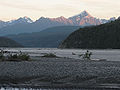
동강 하류에 있는 라프터와 어린이의 빙하

구리강의 피시휠

구리강의 모래언덕
다리에서 남쪽으로 바라본 치티나 근처의 구리 강
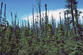
구리강변의 검은 가문비나무
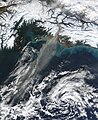
바람은 강둑에서 고운 침전물을 주워 바다 위로 운반한다.


참고 항목
참조
- ^ Smelcer, John (2011). AHTNA NOUN DICTIONARY and Pronunciation Guide (PDF) (2nd ed.). Copper Center, Alaska: The Ahtna Heritage Foundation. pp. 28, 34. ISBN 978-0-9656310-2-0. Archived from the original (PDF) on 14 December 2014. Retrieved 13 December 2014.
- ^ "Tlingit (Lingít, Łingít)". Omniglot. Retrieved 14 December 2014.
- ^ Thornton, Thomas F (January 2012). University of Washington (ed.). Being and Place Among the Tlingit, p. 64. ISBN 9780295800400. Retrieved 2013-03-02.
- ^ "Geological Survey Circular, Issues 491-500". USGS. 1950. Retrieved 14 December 2014.
- ^ Special Ecological Sites IN ALASKA'S EASTERN PRINCE WILLIAM SOUND & COPPER RIVER DELTA (PDF). Anchorage, Alaska: National Wildlife Federation. 2005. p. 6. Retrieved 14 December 2014.
- ^ "Largest Rivers in the United States" (PDF). USGS.
- ^ "Frequently Asked Questions". NPS. Retrieved 14 December 2014.
- ^ a b c Keltie, John Scott (1902). "Recent Explorations in Alaska". The Geographical Journal (Volume 19): 609. Retrieved 14 December 2014.
- ^ Smelcer, John (2011). AHTNA NOUN DICTIONARY and Pronunciation Guide (PDF) (2nd ed.). Copper Center, Alaska: The Ahtna Heritage Foundation. pp. 28, 53 108. ISBN 978-0-9656310-2-0. Archived from the original (PDF) on 14 December 2014. Retrieved 13 December 2014.
- ^ a b Brabets, Timothy P. (1997). Geomorphology of the Lower Copper River, Alaska (PDF). USGS. Archived from the original (PDF) on 3 March 2016. Retrieved 14 December 2014.
- ^ a b Mendenhall, Walter Curran (1905). Geology of the Central Copper River Region, Alaska Issue 41 of Geological Survey professional paper Geology of the Central Copper River Region, Alaska. Washington DC: US Government Printing Office. p. 20. Retrieved 14 December 2014.
- ^ "Copper River Float" (PDF). NPS. Retrieved 14 December 2014.
- ^ a b c Mohlenbrock, Robert H. (2006). This Land: A Guide to Western National Forests. University of California Press. ISBN 0520930517. Retrieved 14 December 2014.
- ^ "Cordova Peak, Alaska". Peakbagger.com. Retrieved 14 December 2014.
- ^ a b c "Chugach Visitors Guide Summer 2014" (PDF). Alaska Geographic. Archived from the original (PDF) on 14 December 2014. Retrieved 14 December 2014.
- ^ a b c d "Human History". NPS. Retrieved 14 December 2014.
- ^ a b "An Alaskan Regional Railroad - 1930's Copper River & Northwestern Railway". Retrieved 14 December 2014.
- ^ Staff. "The Copper River Highway". The Milepost. Archived from the original on April 4, 2012. Retrieved April 23, 2012.
- ^ Google (May 31, 2012). "Overview Map of Copper River Highway" (Map). Google Maps. Google. Retrieved May 31, 2012.
- ^ "Glenn Highway-Tok Cutoff". The Milepost. Archived from the original on 16 September 2014. Retrieved 14 December 2014.
- ^ Lange, Lori (22 August 2014). "corodva, alaska: copper river salmon fishing". recipe girl. Retrieved 14 December 2014.
- ^ "Copper River salmon opening today with first 12 hour fishing period". seafoodnews.com. Retrieved 15 December 2014.
- ^ a b "PRINCE WILLIAM SOUND FRESH WATERS" (PDF). Retrieved 15 December 2014.[영구적 데드링크]
- ^ Van Vanasse, Deb (2009). Insiders' Guide® to Anchorage and Southcentral Alaska: Including the Kenai Peninsula, Prince William Sound, and Denali National Park. Rowman & Littlefield. p. 160. ISBN 978-0762756063. Retrieved 15 December 2014.
- ^ "Federal Subsistence Board News Release" (PDF). Retrieved 15 December 2014.
- ^ "U.S. Fish and Wildlife Service Office of Subsistence Management Fisheries Resource Monitoring Program Estimating Chinook salmon escapement on the Copper River, 2004 annual report Annual Report No. FIS 04-503" (PDF). www.arlis.org/. LGL Alaska Research Associates, Inc. Archived from the original (PDF) on 15 December 2014. Retrieved 14 December 2014.
- ^ "Copper River Sonar Tools". ADF&G. Retrieved 14 December 2014.
- ^ Hagner, Chuck. "Birdwatching at the Copper River Delta in Alaska". Birdwatchingdaily.com. Retrieved 14 December 2014.
- ^ "Species at Alaganik Slough". US Forest Service.
- ^ "Birds Field Trip: Dusky Canada Geese". Ridgefield National Wildlife Refuge Friends Association. Retrieved 14 December 2014.
추가 읽기
- 브라베츠, 티모시 P. (1997년). 알래스카 하류 구리강의 지형학 [미국 지질조사 전문 논문 1581]. 워싱턴 D.C. : 미국 내무부, 미국 지질조사국
외부 링크
| 위키미디어 커먼즈에는 코퍼 강과 관련된 미디어가 있다. |
- 에코트러스트 구리강 계획
- 구리강 연어 서식지 관리 연구 마리 E가 생태탐사를 준비했다. 알래스카 주립 간행물 프로그램 주최 사회경제연구소의 로위
- 알래스카 어류 및 게임 부서: 코퍼 강 연어
- 에이악보존회
- 네이처 컨버넌시: 코퍼 리버 델타
- 구리강 유역 프로젝트
- 구리강 수산업 연구 및 계절고용
- 코르도바 지구 어부 연합
- 브란젤-St. 엘리아스 국립공원 정보
- 구리강 치티나 디프넷 어장 탈출도
| 일반 | |
|---|---|
| 기타 | |