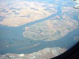
웨스트 아일랜드(캘리포니아)
West Island (California) | |
| 지리 | |
|---|---|
| 위치 | 캘리포니아 북부 |
| 좌표 | 38°01′24§ N 121°46′43″w/38.02333°N 121.77861°W[1]좌표: 38°012424nN 121°46 ″ 43 ww / 38 . 02333 ° N 121 . 77861 ° W / . ; - . ( Island [1] |
| 인접 수역 | 샌호아킨 강 |
| 행정부. | |
| 주 | |
| 자치주 | 새크라멘토 |
웨스트 아일랜드는 캘리포니아의 [2][3][4][5][6][7][8][9][10][11][12][13][14][15][16][17]샌 호아킨 강에 있는 작은 섬이다.새크라멘토 카운티의 일부입니다.좌표는 38°012424nN 121°4입니다.6µ43ºW / 38.02333°N 121.77861°W / 아일랜드[1]1850년 캐드왈러더 링골드가[18] 만든 샌프란시스코 만 지역의 측량 지도와 1854년 헨리 [19]랭지가 만든 이 지역의 지도에 "웨버스 섬"이라는 레이블이 붙은 이 지도가 표시된다.
레퍼런스
- ^ a b 미국 지질 조사 지명 정보 시스템:웨스트 아일랜드
- ^ California State Automobile Association (1999). San Francisco Bay Region (Map). 1:190,000. American Automobile Association.
- ^ "Islands in San Joaquin River for Sale". The Record-Union. Sacramento, California. 1884-11-04. p. 3.
- ^ "Bridge Replaces Ferries in Bay Road Plan". The Sacramento Bee. Sacramento, California. 1921-12-31. p. 21.
- ^ "Antioch Notes". Oakland Tribune. Oakland, California. 1922-07-11. p. 16.
- ^ "Chambers to Boost Great Road Project". San Francisco Chronicle. San Francisco, California. 1922-08-06. p. 12.
- ^ "Sherman Island Bridge Project Gains In Favor". Stockton Daily Evening Record. Stockton, California. 1922-08-10. p. 12.
- ^ "Land Of Great Fertility Is Tapped By New Route". The Sacramento Bee. Sacramento, California. 1925-12-29. p. 20.
- ^ "17 Ships of War Time Set Afire to Clear River". Contra Costa Gazette. Martinez, California. 1927-09-29. p. 6.
- ^ "A Line on the Sportsman". Oakland Tribune. Oakland, California. 1936-09-06. p. 10.
- ^ "Rod and Gun". The San Francisco Examiner. San Francisco, California. 1952-01-30. p. 26.
- ^ "Fishing Now Tops for Striped Bass". Oakland Tribune. Oakland, California. 1958-11-13. p. 56.
- ^ "Delta Fishing!". Concord Transcript. Concord, California. 1967-05-26. p. 11.
- ^ "Outdoor Dateline: Waterfowl rewards few". The Berkeley Gazette. Berkeley, California. 1977-12-22. p. 29.
- ^ "Delta". Oakland Tribune. Oakland, California. 1980-10-05. p. 25.
- ^ "Fishing Report". The Modesto Bee. Modesto, California. 1993-11-11. p. 17.
- ^ "Fish report". The Modesto Bee. Modesto, California. 2004-05-13. p. 34.
- ^ Ringgold, Cadwalader; Stuart, Fred D.; Everett, Chas.; Harrison (1850). "General Chart embracing Surveys of the Farallones Entrance to the Bay of San Francisco, Bays of San Francisco and San Pablo, Straits of Carquines and Suisun Bay, and the Sacramento and San Joaquin Rivers, to the Cities of Sacramento and San Joaquin, California". David Rumsey Map Collection. San Francisco Common Council. Archived from the original on 7 July 2017. Retrieved 25 February 2021.
- ^ Lange, Henry (1854). "Bai San Francisco und Vereinigung des Sacramento mit dem San Joaquin". David Rumsey Map Collection. George Westermann. Archived from the original on 10 March 2016. Retrieved 25 February 2021.


