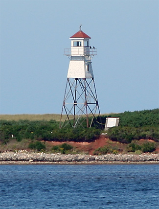
말페크 하버 어프로치 레인지 라이트
Malpeque Harbour Approach Range Lights | |
| 위치 | 호그 아일랜드 프린스 에드워드 섬 캐나다 |
|---|---|
| 좌표 | 46°34′40″N 63°43′11″w/46.577805°N 63.719740°W좌표: 46°34′40″N 63°43′11″W / 46.577805°N 63.719740°W |
| 탑 | |
| 건설된 | 1961 |
| 건설 | 철골탑과 목재 상층부 덮개 |
| 높이 | 15.2m(50ft) |
| 모양 | 발코니와 랜턴을 갖춘 사각탑 |
| 표시 | 붉은 골격의 탑, 흰색 상부 |
| 연산자 | 캐나다 해안 경비대[2] |
| 빛 | |
| 처음 켜짐 | 1961 |
| 비활성화됨 | 2011 |
| 초점 높이 | 16.8m(55ft) |
| 범위 | 10해리(19km; 12mi)[1] |
| 특성 | Iso W 4s |
말페크 하버 어프로치 레인지 라이트는 캐나다 프린스 에드워드 섬의 레인지 라이트 세트다.현재의 후방 탑은 1961년에 세워졌다.[3]
참고 항목
참조
- ^ 프린스 에드워드 섬의 등대
- ^ Rowlett, Russ. "Lighthouses of Canada: Western Prince Edward Island". The Lighthouse Directory. University of North Carolina at Chapel Hill. Retrieved January 9, 2016.
- ^ Rowlett, Russ. "Lighthouses of Canada: Eastern Prince Edward Island". The Lighthouse Directory. University of North Carolina at Chapel Hill. Retrieved August 2, 2009.
외부 링크
- Malpeque Harbour 접근 범위 후면 조명 그림 라이트하우스 프렌즈
- 에이드 투 네비게이션 캐나다 해안 경비대

