알마 8호수 농촌시
Rural Municipality of Lake Alma No. 8알마호수로8번길 | |
|---|---|
| 알마 8호수 농촌시 | |
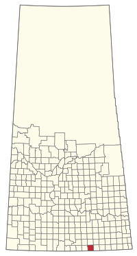
 서스캐처원 알마 8호 RM 위치 | |
| 좌표:49°07′34″N 104°11′38″w/49.126°N 104.194°W좌표: 49°07′34″N 104°11′38″W / 49.126°N 104.194°W[1] | |
| 나라 | 캐나다 |
| 주 | 서스캐처원 |
| 인구조사과 | 2 |
| SARM 분할 | 2 |
| 연방승마 | 소리스-무세산 |
| 지방 승마 | 웨이번-빅 흙탕물 |
| 형성된[2] | 1913년 5월 5일 |
| 정부 | |
| • 리브 | 로드니 로빈슨 |
| • 관리 기관 | 알마 8번 평의회 호수의 RM |
| • 관리자 | 미르나 로세 |
| • 사무소 위치 | 알마 호 |
| 면적 (2016)[4] | |
| • 육지 | 822.47km2(317.56 sq mi) |
| 인구 (2016)[4] | |
| • 합계 | 242 |
| • 밀도 | 0.3/km2(0.8/sq mi) |
| 시간대 | CST |
| • 여름(DST) | CST |
| 우편번호 | S0C 1M0 |
| 지역 번호 | 306년과 639년 |
알마 8호수 농촌시(2016년 인구: 242명)는 인구조사과 2과와 2과 내에 있는 캐나다 서스캐처원 주의 농촌시(RM)이다.주의 남동부에 위치하며, 미국 국경, 몬타나 주의 세리던 군, 노스다코타 주의 디플릿 군과 인접해 있다.
역사
알마 8호 호수 RM은 1913년 5월 5일 농촌 자치단체로 편입되었다.[2]
지리
지역사회 및 지역
다음의 도시 자치단체들은 RM에 둘러싸여 있다.
다음의 비법인 공동체는 RM 내에 있다.
- 지역
인구통계학
캐나다 통계청이 실시한 2016년 인구총조사에서 알마 8호수 RM은 전체 민간주거 112곳 중 99곳에 거주하는 242명의 인구를 기록, 2011년 인구 250명보다 -3.2%가 변화했다.국토면적이 8222.47km(317.56sq mi)로 2016년 인구밀도가 0.3km/km2(0.8/sq mi)에 달했다.[4]
2011년 인구총조사에서 알마 8호 호수의 RM은 250명의 인구를 기록했는데, 이는 2006년 인구 240명보다 4.2% 증가한 수치다.대지 면적 822.47km2(317.56평방mi)로 2011년 인구밀도가 0.3km/km2(0.8/sqmi)에 달했다.[9]
정부
알마 8호의 RM은 매월 둘째 주 목요일에 만나는 선출된 시의회와 선임된 행정관이 주관한다.[3]RM의 리브는 Rodney Robinson이고, 그것의 관리자는 Myrna Lohse이다.[3]RM의 사무실은 Alma 호수에 위치해 있다.[3]
참고 항목
참조
- ^ "Pre-packaged CSV files - CGN, Canada/Province/Territory (cgn_sk_csv_eng.zip)". Government of Canada. July 24, 2019. Retrieved May 23, 2020.
- ^ a b "Rural Municipality Incorporations (Alphabetical)". Saskatchewan Ministry of Municipal Affairs. Archived from the original on April 21, 2011. Retrieved May 9, 2020.
- ^ a b c d "Municipality Details: RM of Lake Alma No. 8". Government of Saskatchewan. Retrieved May 21, 2020.
- ^ a b c "Population and dwelling counts, for Canada, provinces and territories, and census subdivisions (municipalities), 2016 and 2011 censuses – 100% data (Saskatchewan)". Statistics Canada. February 8, 2017. Retrieved May 1, 2020.
- ^ RM 번호별 SGS Sask Cemeteries.
- ^ "2019-2020 Rural Revenue Sharing Organized Hamlet Grant". Government of Saskatchewan. Retrieved May 4, 2020.
- ^ "Saskatchewan Census Population" (PDF). Saskatchewan Bureau of Statistics. Archived from the original (PDF) on September 24, 2015. Retrieved May 9, 2020.
- ^ "Saskatchewan Census Population". Saskatchewan Bureau of Statistics. Retrieved May 9, 2020.
- ^ "Population and dwelling counts, for Canada, provinces and territories, and census subdivisions (municipalities), 2011 and 2006 censuses (Saskatchewan)". Statistics Canada. June 3, 2019. Retrieved May 1, 2020.


